Coastal flooding results from the combination of astronomical factors (sun and moon alignment creating high tides), ocean warming causing thermal expansion of seawater, and long-term sea level rise, with El Niño and marine heat waves further elevating water levels and increasing flood risk in vulnerable coastal areas.
Install our extension to search inside any video instantly.
Monday evening First Alert Weather with Darren Peck 6/15/2026
Added:Okay, Bay Area coastal residents are being told to prepare for higher than normal tides that could flood lowlying areas through Thursday. Sandbags are available at fire stations in Marin County today and some roads were closed last night as a precaution. Fire officials say tides this high up to 2 feet above normal are rare for June.
Heard from a business owner in a spot that's prone to flooding in Salelo.
>> Honestly, I didn't know that we needed to be prepared for that in the summer. A lot of the damage I saw was done in the winter, but I guess it's hard to predict. So, watch your local news, I suppose, so you can stay informed.
>> Absolutely. Watch your local news. But >> I like that guy.
>> But a couple months ago, they were hit pretty hard. The North Bay, Salelo was hit, corner mad was hit, and I mean, a lot of uh flooding where I saw that map that was some of the areas that that could get hit.
>> 101 was inundated back then. It can be easy to forget because so much has happened since then. We broke records then. the all time records. The records we're breaking now for high tide are just the summer records.
>> November to March is when we really get hit. He's right. It's a winter thing, but it is happening now in the summer.
And I just want to give a little bit of insight. There's the uh coastal flood advisory. It's coastside. It's also Bayside, particularly up through Marin.
Take a look at the wave heights. This is part of the story. We do have a swell coming our way which is elevating waves and that's given a little more force to the tide which is already getting a major assist right now because we are at astronomical high tide. Not only are the sun and moon in perfect alignment right now. This also happens to be a point in time when the moon is closer to us than normal. So the tides are getting an assist from that. But let's go back to the map for a second because there's so many things colliding right now to produce what was yesterday a record setting high tide. One of them, which probably isn't getting mentioned enough, the water off the coast of California is warmer than average right now. And when you start to get into these shades of orange and red, that's about a degree or two above average. You warm up the ocean, it has to expand. That means it's higher by an inch or so, measurably because of this. And this is not just an issue right here off the coast of the Bay Area. We can we can step this down out to scale and keep going. Look at all of California. It's downright marine heat wave off the coast of Southern California right now. And for extra credit, we can do this from a hemisphere scale. Look at the sea surface temperatures going all the way down to South America. That's where you are as we almost fly off the set. That big smoky white patch sitting down there, that's Peru. That's El Nino. That stuff is different. That's way above average.
And that will reorient the storm track when we get into winter. We're going to talk a lot about that in the next coming months. What's h come on up here. what's happening up here. This is not El Nino.
This is just what the North Pacific has been doing now regularly for the last decade or so, these marine heat waves.
And now it's kind of coming home to roost because it's warmer and you can get higher sea levels just from that.
And then you got to add that on top of the fact that because of the changes in the ocean over the last two decades with sea level rise generally around the Anyway, it's a complicated story. And that guy had a good point in saying, I really didn't expect this to happen. I'm going to have to start paying closer attention to the nuance stories that you guys are covering. And that's what we're trying to do. All right, let's come back home to the forecast. Look at the marine layer today. Uh it's coming back tonight. I'm going to put this into the futurecast. Uh it we're we're back in June. We're going to do June gloom again tomorrow morning. Watch it fill in the entire bay. Everybody wakes up to gray skies again tomorrow. But don't despair.
We can melt that back. And by the time we get into the late morning, early afternoon, it will be sunshine for everybody. But the beach is in the immediate Golden Gate. We'll put some numbers on it and we'll see daytime highs that actually are much improved from where they were a couple of days ago. We'll start out down at Santa Cruz and Monterey. Uh 67 in Santa Cruz, 66 for Monterey. It's going to be 84 in downtown San Jose. Let's pause for the Inland East Bay for a second. Can we come over here Livermore and conquer?
These numbers are staying in the 80s.
It's actually a little warmer than you were today. You got to warm up a bit tomorrow, but there is a cool down coming for the second half of this week.
And out here, you may not be getting out of the 70s for daytime highs by the end of the week. Let's take a look at the North Bay there. You can see Santa Rosa is already there looking at daytime highs that are topping out in the 70s.
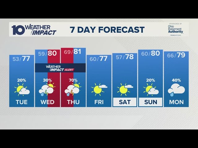
Speaking of that 7-day forecast, let's just go to it. So, we'll start out with the inland microclimate. 84 tomorrow, 80 on Wednesday, and then 70s. What's going to happen? We'll look at this coming up in the next half hour. What's going to happen back here is we're going to get an assist weak area of low pressure coming out of the Pacific is going to help to deepen the marine layer finally and allow it to start filling in those interior valleys in the morning. So, it will be even more June gloom because it's going to get some help. And as a result, daytime highs are only going to be topping out in the upper 70s. Uh we'll look at the 7-day forecast for the bay as well, and you can see a very similar trend. It won't change as much.
You've already been living under the influence of the marine layer for the last several days.
Related Videos

Diy diorama making mini motor water pump science project @SanCreator1
DIYMachinery
9K views•2026-06-13
Monday evening forecast | June 15, 2026
WBNS
384 views•2026-06-15

Lateral shift and apparent depth
surendrapasumarthi
121 views•2026-06-10

Racing Random Cars on the Moon
HudsonsPlaygroundGaming
5K views•2026-06-11

The Cosmic Ghost Passing Through Your Body
Mr.Whizbit
177 views•2026-06-13

The Major Earthquake That Just Hit The Philippines Made A Wave Too Small To Be Possible
AshfallDebrief
122 views•2026-06-10

What if Earth's gravity suddenly dropped by 50%?
IFact-1V1
1K views•2026-06-11

The Temple With Acoustic Secrets
HiddenTruthsDailyreal
686 views•2026-06-11
Trending

This 80 year old corn is dangerous
NileBlue
1569K views•2026-06-10

Everyone around him is insane.
LeoinFrames-1
2406K views•2026-06-13

It does nothing, but men have worn it for 400 years. Behind the origin of the necktie
FineasJackson
1423K views•2026-06-12

Scientists Create Indestructible Medicine
DrBenMiles
628K views•2026-06-11