Effective severe weather forecasting requires analyzing multiple atmospheric levels simultaneously, including 500mb for lifting mechanisms, 700mb for warm front structures, and 850mb for low pressure systems, combined with precipitable water values to assess moisture content and cyclonic circulation patterns that can produce thunderstorms with heavy rainfall, hail, and potential tornadoes.
Install our extension to search inside any video instantly.
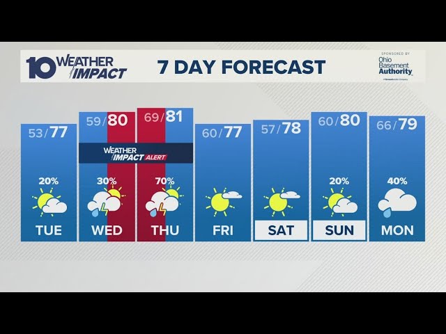
Tranquil Weekend Stormy Monday
Added:Good morning. Welcome to the premium public video forecast discussion for Friday, June 19th, 20126.
Ready for the weekend. We made it through another week.
This is going to be tricky for next week. We're going to have showers and thunderstorms and soccer games and all sorts of things. We got a parade out of way. Congratulation next. Now we have to deal with the World Cup. And with that, they have some interesting factors into whether or not they play a game. So, from what I understand, and I'm not a soccer fan, um I just I'm I'm baseball and football. Sorry. Okay. But but apparently rain fine, lightning bad.
So, well, that mean that makes a whole hell of a lot of sense. So, that is what we're going to be focusing on in our forecast to determine just how stormy it will be on Monday. But first, we have a whole lot of data to dive through on some other things. So, first of all, I just want to go over the CDC data from John Hopkins. Again, I'm a partner with them in which I share some of this information uh which I think uh is important for you to know since for some people I'm one of the few science sources you have. And the thing that you have to watch out for as we go through the summer season and we have our concert series like we have here in Freehold that's on the way that's starting up. uh and you like to go hiking and camping or just whatever heading out to a field but taking out your dog, watch out for ticks. They are on the rise as they typically are this time of year. Uh ticks as we head into into the warm months like we are uh tend to see a pickup in activity. Uh and the one thing you have to really keep an eye on is that getting on your clothes, maybe on your dog collar, stuff like that. And of course it could lead to Lyme disease. So, just be aware, check yourself, check your kids, make sure there's nothing that kind of hitched the ride. And if you are concerned, as always, go talk to your doctor and find out if you have anything that shouldn't be there. Now, let's dive into some meteorology. Hey, we have we had a tropical storm. It lasted for about 15 minutes, but hey, it was there and it developed right around Houston. It is now meandering through the southeast.
You can see it right on the edge here.
Okay. What's remnants of it? There's a chance that the remnants of this could actually well try to develop off the Atlantic coast as it moves through. See, we have the Gulf Stream here and sometimes they can kind of get a little amplified. You know, a little bit of a steroid kick, a little bit of a Super Saiyan kick right there. Uh because it's so warm in the Gulf Stream. The potential there is really low, maybe about 10% or so, but it is there. So, we'll keep an eye on it. It could like uh briefly develop to a subtropical storm and create some havoc for Bermuda or the shipping lanes up here. Other than that, we do have a strong tropical wave that is moving off the coast, but it is going to be running into a very hostile environment. More hostile than, I don't know, a Philly fan going into City Field or a Mets fan going into Philadelphia. That is pretty hostile. Trust me, been there. Um, but that is how hostile it will be with this tropical wave moving into this very dry, sheared environment. So, no development is expected over the next 7 days for anywhere in the tropical Atlantic. But, we'll keep an eye on this little pest before it heads on out. By tomorrow morning, the potential for any type of development will be gone because there's too much shear in the northwestern Atlantic. So, we have that going for us.
And of course, we all know that El Nino is really starting to get its act together. Uh here is the raw data here.
This is the um El Nino 3.4. The observations were at plus 1.377.
Round that up to 1.38 or you can do it up to 1.4. And what you get is pretty close to a moderate El Nino already in place. Pretty impressive. Well on its way to a strong El Nino. Could be historic. We'll see.
As I always say, I don't like to call something historic until it actually is observed in the observations because if you jump the gun, you have egg on your face. So, let's just go with the idea that, hey, this El Nino is going to be rocking and rolling. It's going to have a significant impact on the 500 mibar pattern as we all know and as we've been talking about. What is interesting this morning is some SOI data. This little signal right here, this is why you have to look at all the little factors, right? So we have the monthly value and the seasonal values, right? And these are all negative certainly supporting a moderate uh El Nino influence. This kind of gives us a a pressure view of the influence of El Nino, right? Or Leninia.
So in Lenino, we're looking for positive values. In El Nino, we look for negative values. But you also want to take a look at the daily contributions, which is this right here. This right here tells me we're going to see a little bit of a reload pattern setting up probably around maybe the last days of June or early July. So, let's let's shoot for the July 4th weekend where there could be a little bit of burst of heat maybe, you know, maybe a shortwave ridge providing beautiful weather conditions for July for the July 4th weekend, but also more likely hot conditions as well.
So, we'll keep an eye on this, see if this verifies. But typically, when I see a persistent negative anomalies like this, which is typical for the daily values, and then you see this pop to a positive, take about 7 to 10 days out, and you could start to see that influence on that. So, let's say from June 29th into the July 4th weekend, you could end up with a bit of a boost in your temperatures to more of above normal, maybe more dry conditions.
Not that we haven't seen dry conditions, but more dry, okay, more sustained high pressure system, more no real threat for thunderstorms, that type of scenario.
So, we'll see how this all plays out.
Now, talking about showers and thunderstorms as we begin our discussion and look at our weather pattern and we'll pull up the 500 mibar pattern and you can see here that yeah, there's definitely going to be a trough in the east and a threat for showers and thunderstorms. Here's why we don't jump the gun on five to 7day convective forecast with big tornado signals and all this sort of nonsense. And a great example was yesterday. Yesterday we had even 48 to 66 hours out, right? Uh the potential for strong maybe even severe thunderstorms for the northern Atlantic.
We got zero. Why? Because we we learned this actually on Wednesday night. I brought this up that this was a potential outcome. You had stronger forcing and more convective de development in New England yesterday with showers, thunderstorms, tornadoes, severe thunderstorms. You had the same thing kind of evolving around Virginia and we were caught in between which led to substance synoptic models i.e. large scale models that deals with uh large wave troughs like what we're looking at here and generally models that go into the 5 to 7 range and medium range do a horrible horrible job handling convective precipitation especially with the potential for rising and seeking motion. how that could influence development and location of thunderstorms, outflow boundaries, all that type of stuff. So, you do not get, what's the word? Overexited, making outlandish statements, uh, claiming that this is going to be the worst scenario ever. You don't do that, okay? In a medium-range forecast. Yes, there's a threat for showers and thunderstorms, but the forecast is always more complicated than that. So, I want you to keep that in mind when we talk about Monday. I'm going to break down some of the things I'm seeing and some of the outcomes that we could see as a result of this. So, we have right now excellent weather conditions for the most part over the interior. We're clearing skies and temperatures in the mid to upper 60s, upper 60s to lower 70s in the northern suburbs or north of I95 corridor along and south of the I95 corridor. We're generally in the lower to mid70s riding along this cold front.
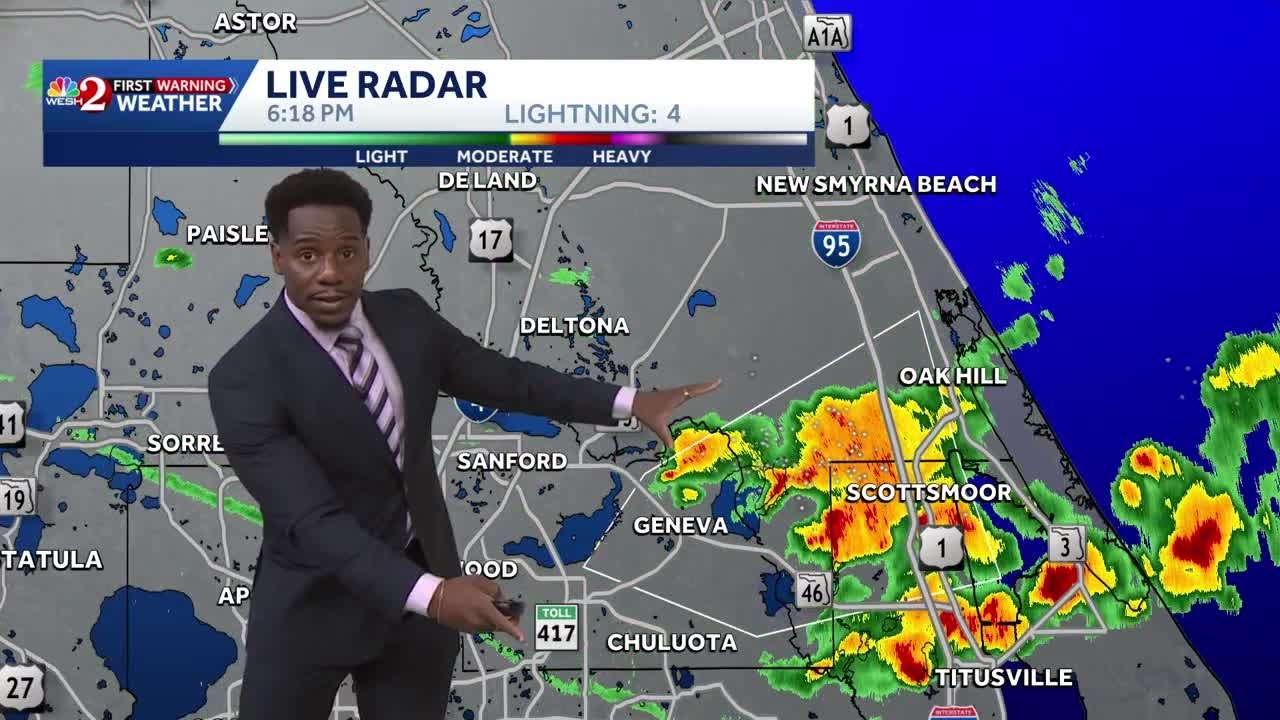
Right. So, this cold front is going to lead to variable cloud cover, a few showers here and there. A lot of this really is uh more bark than bite. When you compare this to the observations, you got a lot of lot of cloud cover absolutely, but not much in the way of rainfall. A moderate downpour here and there, but nothing that's really too impressive. We also see that on our uh radar from Weatherfront. I like using this is if you're new to the Weatherfront guys, I actually met them in the AMS. Uh great app. You do have to pay for it though. So just remember that. Uh but it is well worth it, right?
Um and and uh very interesting data. And what we could see here with this data, if we take a look at our new sounding here, we'll generate it right now live while we're doing this. You see this?
That's dry air transport. And ladies and gentlemen, that is going to cascade from the interior down to the coast. And that is what we're seeing here on our visible satellite picture. Dry air slowly building. You can see the low clouds kind of breaking up more thicker low clouds along the coast. So as we move on through the day, we'll see a gradual increase in sunshine as the cooler, drier air builds in and the rainfall exits. So again, still a threat for a few isolated showers here and there, but nothing that is going to ruin your day.
And as you can see on the infrared satellite picture, which is just updating, there is our disturbance.
There is the remnants of whatever our tropical storm used to be. that is going to push off the Carolina coast, head out this way. No direct impact on us. Want to make that very, very, very clear. No impact on us. It kicks out. So, that's gone. What follows for the weekend is this beautiful weather right here. And then trouble back here. You can see that right here on the water vapor satellite picture. Hello. How you doing? Nice little short wave, rather vigorous one, which is typical of El Nino years, right? where we're going to get this vigorous short wave diving in and interacting with the subtropical jetream. And that is where things get interesting for Monday. Now, at 500 millibars, the one thing I noticed for Monday is the strongest lifting is all focused to the north of us. Hm. I think I've seen this before. I have yesterday where we saw a lot of forcing and a lot of your better dynamics focused towards the St. North River Valley and towards uh New England. Meanwhile, we go down to 700 millibars during that same time period. And this signal right here is typically occlusion, warm front somewhere around here, and cold front somewhere around here. So you have this convective signal showing up here. So warm front usually leads to what we call stratform rain, steady rainfall, and that looks to be over New England and Connecticut. Then you get a little bit of a break in the lifting and then some sort of cold front structure in here. Now let's go take a look at 850 millibars during this time period. And look at that. The 850 low is to the north of us. So this is more likely to drive the more unstable conditions northward and a nice southwesterly wind. Again, going back here for a second, 700 millibars southwesterly, 500 millibars westerly. And again, notice the curvation here. So, there is potential here for more of a cyclonic circulation with our winds. Keep that in mind. Okay. So, we have all that set up.
And with the 850 low, this would tell me that, hey, warm front structure lifts northward, cold front structure approaches from the west. This signal is showing up repeatedly. Then we add in precipitable water values. And boy oh boy, when you see this type of signal, this is juicy. This is basically, think of it like this. You have a sponge, you take the sponge, you drop it in the water, you soak up the water, you squeeze out the sponge. That is basically the potential for some very heavy rainfall. So this tells me, hey, look, there's a potential here for a tropical type air mass. Okay, so let's put this all together. We have a warm front lifting northward. We have a cold front approaching from the west. We have a lot of moisture. we have veering winds and at the surface we have southerntherly winds.
So you have a cyclonic circulation. So that opens up the potential for meoscale lows and thunderstorms capable of tornadoes. Uh you have the potential for a lot of mixing involved, a lot of rising motion with a lot of deep moisture.
But there's a catch, the warm front. So, let's take a look at 700 mibar relative humidity because this kind of tells me a lot here. This tells me like, hey, we might have a difficult time clearing out because this warm front may be taking its time moving northward around the region. It does temperatures jump, [clears throat] but it might not be enough to give enough timing for instability.
So that is a bit of a problem in this forecast. And so when we take a look at the uh European right now because we can't use the name or the RRF FS or whatever the heck they want to call it.
You certainly can't use the HR RR uh which I always like to call the pirate model because HR, you know, but [snorts] those models are too far out, right?
Those models do not do not do well this far out. Many of them do not even go out this far. So you really can't use them for any type of analysis. So don't. So with that, we have to use the European.
And with that, you could see the warm front here trying to push northward. So this is a scenario where the warm front is going to move through on Monday morning into early Monday afternoon. And where that warm front stalls, that's where we're going to see periods of rain, which right now looks to be focused around Connecticut, the Catskills, the uh Poconos, northern New Jersey, maybe the northern part of the Hudson of the Hudson, Long Island Sound, right? So you got your warm front right around here. To the south of that warm front, you have tropical air masses trying to surge northward, but you also have a lot of cloud cover and debris showers. So this might hinder the instability potential, but because of all this deep moisture, if we get enough clearing and if we get enough destabilization with this cold front that lifts through, we could end up with some thunderstorms that can feature some very heavy downpours, hail, frequent lightning, um wind gusts, certainly between 40 to 70 mph, and yes, maybe an isolated tornado because because we have the scenario here, unlike the other event where all the winds were coming from the same direction from the west southwest. This time you have winds at the surface from the south at 850 to southwest and then at 500 millibars to west. So when you have that type of cyclonic circulation you open up the potential not the guarantee but the potential for meascale lows and a tornado. So yeah, it's going to be excellent conditions for the wild for the World Cup games in Newark, New Jersey and Philadelphia, PA. Yeah. So if you are going to those games, have a backup plan and uh there is a chance that you might actually have to suspend the game, pause the game because of not the rain, but because of the lightning and the thunderstorms associated with that. So that is something to uh definitely keep an eye on. So, let's walk through this forecast for today.
Look for variable cloud cover, gradual clearing as we go on through the day with high temperatures in the mid to upper 70s over the northern interior, lower to mid 80s along the I95 corridor and towards the coast. For tonight into tomorrow morning, look for sky cloud cover with low temperatures in the mid to upper 50s over the northern interior, lower to mid60s along the coast.
Tomorrow afternoon, sky cloud cover, beautiful weather conditions. Go out there and enjoy it after you watch the videos. And of course, check out all the content at nyjpawe.com.
Look for high temperatures in the mid to upper 70s over the northern interior, lower to mid 80s along the coast. For Sunday, sky cloud cover, maybe an isolated shower or two with a trough, but for the most part, just a mix of sun and clouds with low temperatures in the mid to upper 50s over the northern interior, lower to mid60s along the coast. High temperatures in the mid to upper 70s over the interior, upper 70s to lower 80s on the on southeastern Long Island and mid to upper 80s everywhere else. Then we get to Monday, which we talked about in depth. Look for showers to develop on Monday morning becoming widespread with the warm front. Look for low temperatures in the mid to upper 50s over the northern interior. Lower to mid60s in the suburbs, upper 60s to lower 70s in your urban area, especially around Philadelphia. Then on Monday afternoon and evening, the cold front moves through with showers and thunderstorms. Some of them could pack quite a punch. We'll keep an eye on that. Look for high temperatures ranging from the mid to upper 70s over the northern interior and on Long Island, upper 70s to lower 80s on the I95 corridor. If we see a little bit more sunshine though, those temperatures may be a bit higher. So don't be surprised we break out some sun around Philadelphia, we jump to 88 and if it's like a sauna and then the thunderstorms move through. So there's a lot of variability here on the forecast on Monday. On Tuesday, we all clear out with sky cloud cover and low temperatures in the upper 50s to lower 60s over the northern interior, mid to upper 60s along the coast. High temperatures will rebound into the lower to mid70s over the northern interior, upper 70s to lower 80s along the coast.
On Wednesday, look for sky cloud cover again with low temperatures in the mid to upper 50s over the northern interior, lower to mid60s along the coast, high temperatures in the mid to upper 70s over the northern interior, and upper 70s to lower 80s along the coast. Notice no sign of any heat waves here in this pattern. That's going to be typical for much of this summer. Then we get to Thursday and that is when we're going to have an area of low pressure pass through the region with scattered showers, possibly an isolated thunderstorm. Look for low temperatures in the upper 50s to lower 60s over the northern interior, lower to mid60s along the coast. High temperatures in the mid to upper 70s over the interior and on Long Island, lower to mid 80s on the I95 corridor. And next Friday, unfortunately looks to be a bit unsettled with scattered showers, possibly an isolated thunderstorm or two with a weak area of low pressure moving through. This looks more bark than bite here. Remember when we are dealing with mild guys this far out, it does a really poor job at handling convective systems, thunderstorms. So it produces a thunderstorm and just kind of bleeds it out all over the place. So again, scad showers, maybe isolated thunderstorm or two. Not a complete watch out. Look for low temperatures in the mid to upper 60s, high temperatures in the lower to mid70s. That's your forecast discussion for today. Have a wonderful weekend and as always, stay safe out there.
Related Videos
Monday evening forecast | June 15, 2026
WBNS
384 views•2026-06-15

Monday evening First Alert Weather with Darren Peck 6/15/2026
cbssf
662 views•2026-06-16

Clouds build up tonight as we track a storm threat for Thursday
NBC10Boston
2K views•2026-06-17

Just One magnetic field power, two light start with Armechar • Dc Armechar
DcArmechar7
14K views•2026-06-17

What a Massive Blue Iceberg Actually Looks Like?
QuickLearnGeography
100 views•2026-06-18

Chicago Morning News at 7 a.m. - Monday, Jun. 15, 2026
FOX32Chicago
942 views•2026-06-16

The Terrifying Physics of High Blood Pressure
fleshandwonder
1K views•2026-06-15
Strong And Severe Thunderstorms Surge Across Central Florida To Finish the Workweek | Stormy Week...
WESH
806 views•2026-06-19


