A strong thermal gradient (temperature difference) between regions creates a powerful jet stream that drives severe weather systems; when strong winds aloft move across plains, they develop low-level jets that enhance thunderstorms through wind shear, potentially producing damaging winds over 50 mph and tornadoes in areas like Kansas, Nebraska, and Colorado.
Install our extension to search inside any video instantly.
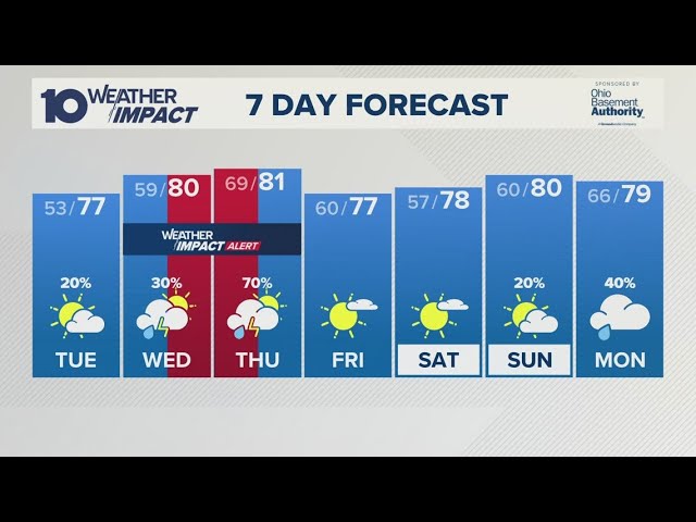
Rough Weather Keeps Coming Back - Changes Ahead
Added:A pretty strong thermal gradient. That's the temperature difference that we're seeing across the Southwest and the colder air across Canada has been creating a really strong jet stream that has impacted the weather of the last couple of days through the past week.
That's put a lot of severe weather that we've seen into parts of the Midwest, also into the Ohio Valley. Today, we're watching another jet streak swing out of the Rockies thanks to this temperature difference. It's not going to be nearly as strong as last week, but here's the difference though. Once we get this the stronger winds aloft moving across the plains, we're going to develop a pretty decent low-level jet at the low levels of the atmosphere.
And that wind shear, that difference in wind speed with height is going to enhance the thunderstorms as we head through this afternoon. The thunderstorms will likely be high based across parts of Wyoming and Colorado.
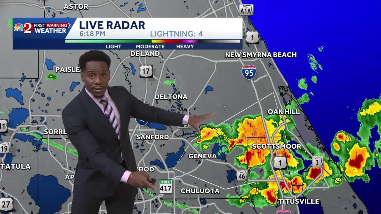
And then, as that strong southerly jet starts to develop, we're going to see the potential for some damaging winds that could gust over 50 mph across parts of Kansas, Nebraska, Colorado, and the tornado risk is here as well. So, watch out here in the northeast Colorado, especially here in the Kansas and southern parts of Nebraska, as far south as the panhandle of Oklahoma, and as far east as parts of Missouri as we head through the evening hours. Let's take a look at the future radar.
We're going to break this down a little bit hour by hour. We'll go across the rest of the country, too, and we'll talk about what's happening. Here's where we're where we're headed through the afternoon. Relatively quiet, I would say. Maybe a few thunderstorms across parts of Nebraska, a little cloudy here.
That will actually help keep things a little more stable, especially across northern Nebraska into South Dakota.
But, here comes the energy with storms popping across Wyoming, further south along the front range, especially from Denver east. These storms could get really big, too. The upper-level winds, we looked at that, are coming in really like this out of the west. So, your storms are getting driven that way. Your low-level southerly jet really starts to increase, and that's going to increase that helicity, that spin in the atmosphere. So, tornadoes looking like it could be another day of tornadoes, I should say, across Kansas, also into parts of further south into Oklahoma.
Watch these cells. Be weather aware as we head through the evening hours.
Across the Gulf Coast, it's cloudy.
Further to the north across Texas, all the way, I don't know, along the I-40 corridor, looking pretty good, relatively dry, a lot of blue showing up here, so that means clear skies and some sunshine through the day on Saturday into the evening hours, but it's again, it's really active here across the central US. Let's let this go out a little bit further. These storms will hold together and they'll be going through parts of Kansas into Missouri with some really heavy rain as we head into Sunday morning. Uh and that those storms will continue to push off to the east as we move through the day on Sunday into parts of Illinois, Indiana.
As we look at the Storm Prediction Center's outlook for day two, we are watching a little bit further to the east, so storms possible further south, too, across Oklahoma into Arkansas, possibly as far east as Kentucky and Tennessee, Indiana, All of these regions could see some strong storms, maybe a few tornadoes as well, especially as these storms continue to ramp up again as into the afternoon and evening across Illinois, Missouri. And hey, listen, some of these storms through the early morning hours uh could be on the strong side uh moving through parts of east Kansas, also into Missouri. Once we head into the afternoon, we'll watch this line try to get going uh by 2:00, 3:00, 4:00, and then everything starts to push off to the east into Illinois. We we're doing it again with more severe weather here.
The good news is, I guess, if there's a silver lining, your upper-level winds aren't as strong as they were the other day. Further to the west, we've got the storms again we've talked about up in this region, but look at all the shower activity. A little bit of rain possible from parts of Idaho. Again, not a lot.
Back to the west, even to all the way to northern California, not a lot of moisture, and then we're seeing some colder weather start to drop into the northern Rockies with showery conditions up into this region and maybe maybe a little bit of snow trying to fly up into the high mountains of of the Canadian Rockies where it is pretty chilly.
Let's go further to the east. We we want to look at what's going on here, too. We've got a lot of showers trying to pop through the afternoon on Saturday. I'm going to back this up. The new model run just came in if you're joining the live stream.
Welcome if you're checking it out on playback.
Again, there are some errors. It's live.
We're not cutting anything up here. So here we go. Through this afternoon, there's the showers across the deep south. Hey listen, quite a bit of sunshine here in the Mid-Atlantic, but there could be a few showers trying to pop this afternoon into the evening hours across parts of Ohio further east into Pennsylvania and up into Michigan.
Also into the northeast. It's not going to be a complete washout, but there will be showers and some thunderstorms around and then as we head into the evening hours, things start to calm down some. A little more cloud cover across the Ohio Valley into Ohio, Indiana, into Michigan as we get into Sunday morning. Steady rain it looks like anyway from Chicago west across northern Indiana, also into Iowa and farther to the east, a lot of sunshine across the Carolinas, also into parts of West Virginia. High clouds starting to increase here, but overall a pretty nice day up to the northeast. Clouds definitely on the increase out ahead of this next complex of storms and then the weather does start to change especially as we head into Monday as our front stalls out. Rain is back into the Tennessee Valley and that starts to spread a little bit to the east. Here's a look at your rain totals as we head through all the way into this week into Thursday.
Quite a bit of rain across a lot of the country at least here across the the mid-south into the the Midwest. Not quite into the upper Midwest, not nearly as much rain, but there will also be some rain into the northeast. Good news is drought monitor looking a little better in many areas. Still a little dry into parts of the upper Midwest. This is looking better here into the southeast.
I get it. Along the Gulf Coast here into Florida, still really dry into this region. Right along the coastal plain of South Carolina into Virginia, the Piedmont of North Carolina. And do we even need to talk about how dry it is across the West after a really dry winter? It's no wonder that we're seeing the short and long-term drought continue across this region.
Widening things out as we head through the weekend, there's the cold weather.
Look at this. This is again driving some of those some of that jet stream that we've seen that's been really strong across the United States. The good thing is that is that that's starting to relax a little bit, but snow levels, interestingly enough, are starting to drop here into parts of Alberta down to about 6,500 ft.
Hey, good news if if you are skiing. If you missed the video about Sunshine Village, they're doing skiing there in Western Alberta up in the Canadian Rockies. I'll put a link to the description below after the live stream.
You can check that out. Really a wild snow season here in the British Columbia. It was a different story across the West. I know through the winter, we talked a little bit about that in the video. So, check it out if you missed that. As we head into Sunday, then again, we've talked about the severe weather. Showers farther to the north, that pushes out into the prairies of Canada as well. So, we'll start to see some rain into Saskatchewan and further back to the west into Alberta.
And then rain moving east, dry along the Gulf Coast. We're drying out especially after that tropical system Arthur moved through.
And then overall, though, kind of dry across the Gulf Coast states. Your front doesn't really come that far to the south, but we will start to increase the chance of rain across the south as we head into Wednesday and Thursday as your front sort of dies out here. And then in the upper levels, your northwest flow, I mean, it's not going to get let things get super hot across the upper Midwest. Maybe some good news here as we stay relatively cool. I mean, it could be blistering hot, but that's that doesn't seem to be in the forecast for now.
It is going to be hot along the East Coast today. We're talking about 90s along the lower country of South Carolina, at least upper 80s to low 90s and mid-80s. It could be much hotter here, too. We could be baking in the mid-90s. Overnight tonight, nice and comfortable. I mean, look at these numbers here in the interior areas dropping into the 50s, maybe even some 40s farther north into Michigan, into the UP, all the way up here into the area ahead of Minnesota.
Nice and crisp waking up Sunday morning.
Highs will be pleasant into the 60s and 70s, a little warmer across the Carolinas, back into Tennessee with some more 90s showing up on Sunday. And then here's a look at Monday morning. A little muggier in some areas and the the heat. Again, mid-80s today, mid-90s, I think, as we head toward Monday for DC, Baltimore, south to Richmond, down to Raleigh, and all along Florida.
It's always hot in Florida this time of year.
Highs yeah, back into the 90s again.
Also across the deep south, southern Alabama, southern Georgia, southern Mississippi into the 90s. A little more rain keeping temperatures back into the 70s, at least chances for rain and clouds across Mississippi, Tennessee, back through Arkansas with highs held back. Wherever you see the clouds, it's going to clearly be a little cooler.
Here's where we where we're going to end up today, I think, across west Texas, where it's going to be pretty hot. Take a look at these temperatures across Colorado, up into Kansas.
Really hot weather here. And you saw the severe weather that's moving through.
So, there's some concern. There's going to be a lot of energy in the atmosphere heading into this afternoon, overnight tonight. Lows not getting very low and another hot day tomorrow. In fact, the heat expands into parts of Texas into the 105 to 110 range in some areas.
Across the west, cool up here into the northern Rockies, 50s and 40s even at the high elevations. Hot across the southwest. There's that cold weather moving into the northern Rockies, especially up here into the Canadian Rockies with overnight lows dropping into the 30s, snow levels dropping nearly to 6,000 ft. And then tomorrow highs will be in the 40s and 50s, cool and damp. A little warmer to the south from Boise down into the valleys into the Eastern Washington and Oregon close to 90 in some of these areas into the Central Valley of California in the upper 80s and low 90s while places like Tucson, Death Valley, the Grand Canyon region, Vegas baking in the heat across the Southwest.
And that's going to continue as we head into next week. In fact, if anything, the warmth may spread north into Colorado and Utah as highs climb well into the 90s.
All right, that's a quick look at the weather across the country as we head through the next couple of days. Again, if you missed the summer skiing video, I'll put a link to it right here. Check it out. We're We're talking about the snow that that's falling right now and that's really not the story. We talked about the big snow that fell over the winter that's still on the ground. And they're still going to ski. It's wild.
Check it out. Thanks for watching, guys.
Thanks for your support.
We'll see you next time.
Related Videos
Monday evening forecast | June 15, 2026
WBNS
384 views•2026-06-15

Monday evening First Alert Weather with Darren Peck 6/15/2026
cbssf
662 views•2026-06-16

Clouds build up tonight as we track a storm threat for Thursday
NBC10Boston
2K views•2026-06-17

Just One magnetic field power, two light start with Armechar • Dc Armechar
DcArmechar7
14K views•2026-06-17

What a Massive Blue Iceberg Actually Looks Like?
QuickLearnGeography
100 views•2026-06-18

Chicago Morning News at 7 a.m. - Monday, Jun. 15, 2026
FOX32Chicago
942 views•2026-06-16

The Terrifying Physics of High Blood Pressure
fleshandwonder
1K views•2026-06-15
Strong And Severe Thunderstorms Surge Across Central Florida To Finish the Workweek | Stormy Week...
WESH
806 views•2026-06-19


