Weber offers a clear look at how competing models create forecasting uncertainty, highlighting the difficulty of predicting atmospheric transitions. It’s a grounded reminder that even advanced meteorology must grapple with the inherent chaos of weather systems.
Install our extension to search inside any video instantly.
Arthur remnants may become subtropical system
Added:Thanks for logging on to my foxhurricane.com. Still watching the remnants of once Tropical Storm Arthur.
Still bringing some rain across portions of say southeastern Georgia. Some of this rain spreading back into Alabama and then working its way up the coastline and we're going to continue to watch this over the next several days because it's not quite done just yet. You see the heavy rain right now. In fact, we have had some flooding across southeastern Georgia. You see some of this rain extending back into central and southern Alabama. A few little showers into northern Florida as well.
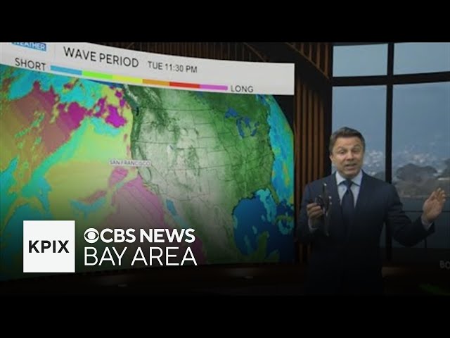
So, we have the flash or the flood watches out and then there you see those flood advisories, some flash flood warnings in there as well. So, we continue to watch many of these areas just been which have been soaked with uh not only inches, but tens of inches of rain. And as we go through the next few days, you're still seeing some of these areas that have had so much rain over the past several days getting an additional 1 2 3 inches of rain. Not necessarily from Arthur, but we have this front that has worked its way down across the south. So, it's just that typical rain. But, they've had so much rain, we're going to see additional flooding in these areas or at least that potential that we see additional flooding. So, here is basically the center of the remnants of Arthur. Now, it's going to work its way back over the Atlantic. That's when we start to get that big question if anything happens with this because we have some of the models hinting that maybe it tries to redevelop, maybe it becomes a subtropical system as it works its way across the central and eventually heading into the North Atlantic. So, Hurricane Center putting about that 10% chance of some sort of development with it. And you look at the different ensemble models. It's really a good tool to give you that that that sense of how much certainty we have in the forecast.
So, we're looking at the European ensembles in red, the GFS ensembles in green, and one thing you notice right off the bat, uh they're really having a hard time just figuring out exactly where that starting point is with this, and so it's hard to get a really accurate forecast if you can't even figure out exactly where that starting point is, but that general idea you see the models are really split on this, especially the GFS. Uh a lot of these L's just kind of stop moving, which tells you the model is basically just doing away with that system, really not developing it. The European holds on to this a little bit more, but still very split on if anything will eventually happen with it. So, it's just one of those things we're going to wait and see over the next several days. The good news is regardless of whether it develops or not, it's moving away from the US at that point, so it not be of any concern.
Elsewhere in the tropics, you see just a line that's Saharan dust continue to work its way across the eastern and central Atlantic, working its way into the Caribbean. In fact, you look at live camera down in the Caribbean. Here's in the Virgin Islands, and you do see the some of that hazy look as that dust is working its way. And so, these areas they will stay quiet over the next several days, so we'll keep you updated right here on myfoxhurricane.com.
Related Videos
Monday evening forecast | June 15, 2026
WBNS
384 views•2026-06-15
Monday evening First Alert Weather with Darren Peck 6/15/2026
cbssf
662 views•2026-06-16

Clouds build up tonight as we track a storm threat for Thursday
NBC10Boston
2K views•2026-06-17

Just One magnetic field power, two light start with Armechar • Dc Armechar
DcArmechar7
14K views•2026-06-17

What a Massive Blue Iceberg Actually Looks Like?
QuickLearnGeography
100 views•2026-06-18

Chicago Morning News at 7 a.m. - Monday, Jun. 15, 2026
FOX32Chicago
942 views•2026-06-16

The Terrifying Physics of High Blood Pressure
fleshandwonder
1K views•2026-06-15
Strong And Severe Thunderstorms Surge Across Central Florida To Finish the Workweek | Stormy Week...
WESH
806 views•2026-06-19


