This analysis masterfully distills complex atmospheric dynamics into a clear narrative on how thermal gradients fuel severe weather. It is a prime example of professional meteorology bridging the gap between academic theory and public safety.
Install our extension to search inside any video instantly.
This weather feature is a problem maker!
Added:This weather pattern is a problem, and it's the problem maker behind it that's really causing the severe weather that we saw yesterday and that we're probably going to see again today. Now, let me talk about something that is not necessarily related to what we're seeing right now, but it could be related to what we're going to see this winter.
You've heard about that El Nino, super El Nino, whatever you want to call it.
Strong warm water in the Eastern Pacific is going to start to set up. Now, here's the thing, right? I just just follow me for just a second. You're going to get really cold across North America. You're going to have some really warm temperatures across the Eastern Pacific.
That drives a really strong jet stream.
We're kind of seeing that right now.
Although, it's not the El Nino. It's the fact that it's so darn cold up here across Canada, way below average, and we've just seen this really warm weather that typically develops this time of year, nothing abnormal about this, across the United States, especially across the Southwest. That is driving this huge jet stream into the country.
This is what's driving severe weather.
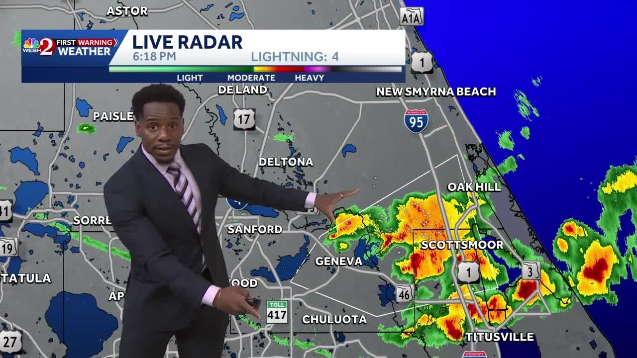
There's been tornado warnings even through the morning on Thursday into places like West Virginia. Today, there's going to be more severe weather into parts of the Northeast, also into the South. This is related to what's left over of Arthur is this tropical depression now moving inland. Some stronger storms going through the morning hours, and there could even be more this afternoon. Damaging winds, hail. The problem will be some tornadoes, too. Further to the east now, we're looking into the Northeast. A different look here, right? With a tornado risk into Vermont, New Hampshire, parts of New York, even Southern New England, parts of Connecticut and Rhode Island. But, here into Vermont, New Hampshire, that's an area that we need to watch this afternoon, and then across the South, specifically right here across uh lower parts of Alabama into Mississippi and the panhandle of Florida, as far north as Georgia, places like Macon, all the way up into South Carolina. So, we're going to talk a little bit about that, but before we do, let's go ahead and show you what the weather pattern's going to do as we head into the weekend. This cold air is going to continue to pinwheel here just south of the Hudson Bay, keeping things cool here across a good 2/3 of Eastern Canada, also across the northern US from the Upper Midwest, the Great Lakes, all the way into the Northeast with clouds and again below normal temperatures across the West into the Southwest, temperatures here above average. We are going to watch a a decent ridge start to build in across parts of the Northwest, so temperatures do start to go back above average here. And what we do see is this really cold pocket of air that's spinning out south of the Hudson Bay starts to relax. So next week looks dramatically different. Still a pretty strong jet stream screaming here out of the North Pacific, right? This is is a pretty ominous looking and that's driving some colder air and maybe some disturbed weather here into Western Canada. We're talking about British Columbia, Alberta into the Northwestern US, Washington, Oregon, possibly the Northern Rockies with some colder weather and does this set up for some severe weather farther to the east into the prairies and also into the Northern Plains. More to come. That's really long range, but that's a quick look at the weather pattern. Let's talk about where the rough weather's going to be today.
This squall line here has been super impressive since yesterday. This was the tornado maker that we saw from Illinois, Indiana, Ohio, uh back in the Missouri.
This is dropping south through the morning hours. It's actually starting to stall across Kentucky and now I think heavy rain is going to be a problem as these storms train right along that front. To the Northeast, it's a different story. We've got this low This area of low pressure that's lifting just north of Lake Erie and Lake Ontario. As it does so, out ahead of it it's bringing in some southerly winds. You're getting that jet stream aloft with those winds moving in out of the west-southwest. That change of wind direction with height is going to help these storms to rotate. So as they grow up in size, they're going to want to spin up. So that's the problem with tornadoes into this region as we head now into the afternoon. Also, the same thing is happening just at a bit of a different scale across the South with this spin in the atmosphere thanks to what's left over of Arthur. So that could cause some tornadoes across Again, parts of the South that we just talked about. Further to the north, some storms could get really strong in this region too with some damaging winds. Not as much twist in the atmosphere, but enough still with that strong jet stream moving through thanks to that really cold air aloft that's up into the Great Lakes and north of that into Canada. So, more severe weather today again.
As we head into tonight, this area of low pressure, what's left over of Arthur, spins through the south. Some really heavy rain possible here. Will it interact with this front and enhance some of the heavy rain to North Carolina through tomorrow morning? I think it could and then we start to clear out, at least for the northeast. Notice the blue starting to show up. That's clearer skies, so we do get rid of the cloud cover.
Some cold air aloft could trigger a few afternoon showers and storms as we head into Friday. You can kind of see how that's popping up into this region.
Otherwise, much drier across this region heading into the afternoon and now we've got another round of showers and storms as we head into Friday night dropping in from the northwest across Wisconsin also into Minnesota. Let's go farther to the west now. There comes what's left over of Arthur ashore here across the Gulf Coast states. That will continue to lift to the north. It's going to bring some again, some really heavy rain to parts of the Gulf Coast states in the order of several inches.
In fact, let's pop over to that before we go any farther. The heavy rain here, three, four, five, maybe even locally up to six inches of rain into parts of Alabama, Mississippi, also farther east into Georgia and that heavy rain. I think you know, up here in the North Carolina, the rain could also get heavy at times as well as this low lifts north. To the north, we've got a few showers and storms across parts of Oklahoma. That starts to calm down though as we head into the overnight and then some big storms showing up overnight here across Oklahoma. That's an interesting look as this piece of energy swings through here along the Red River farther east into Arkansas as we head into Friday and then once we get into the weekend, well, more on that in just a second.
Let's we'll take a wider look at North America and a quick look out west where it's kind of quiet right now. Maybe a few afternoon showers and storms going here into the southwest along the Grand Canyon rim up to Flagstaff, south and east into parts of New Mexico. A little more moisture here and there could even be a few showers and storms firing along the Sierra. Otherwise, really dry here across the Great Basin, also up across the northern Rockies into the Canadian Rockies into the Pacific Northwest.
Things change tomorrow as this low moves ashore, so that's going to bring some showers, maybe some storms, too, here into parts of the west. More on that uh ahead as we head through the weekend for this region. A quick look at the rest of the continent all the way up into parts of Canada. There's that really cold air just sitting and spinning and there's that strong jet that's just continuing to bring that cool air here into the north uh northern parts of the US. Across the Southwest, it is hot.
But look at the blue starting to show up here along the British Columbia, Alberta border. Some colder air sneaking in for Saturday. It's going to drop your temperatures at least into parts of Montana, also up here to this part of Canada. And as this system moves east, it could bring some more strong storms as we head into the weekend. Rain is back across a lot of the east as we head towards Sunday, also into Monday. So, really active over the next couple of days. We've talked about the rain. Let's talk about the warmth that we're going to see this afternoon. Hot along the Piedmont down to the coastal plain of the North Carolina, South Carolina, up into Virginia, even up into the Delmarva. Highs will be close to 90 in many areas, even DC. Tomorrow, a little bit cooler here as winds start to shift a little bit.
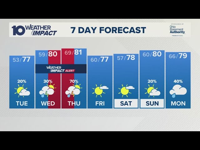
Highs will be in the 70s and 80s.
Overnight lows 50s and 40s for farthest to the north. And then a little bit cooler looking in many areas that today will be pretty darn hot.
Back into Texas, a hot afternoon. Triple digits here from West Texas, Central Texas, Austin. It's going to be baking here. San Antonio up to Dallas. The dividing line is here across southern Oklahoma. As this front drops to the south, tomorrow with a little more cloud cover, highs will be held back into the 80s. It's going to be sticky, though.
Especially where the air mass doesn't really change much and you're just going to see the rain around.
And then as we head into Saturday, starts to really heat up here along the front range near the Denver, down in Colorado Springs, we're talking about 90s here and even back into Utah and into Salt Lake City getting really hot here across the west with highs well up into the 80s and 90s here in the lower elevations of Utah and into parts of Arizona, Southern California. Here comes some of that cooler weather starting to show up as we head into Saturday. Look at these highs up here.
Again, into the 30s into the mountains of British Columbia and Alberta. Some of that cool air does drop further further to the south into Montana with overnight lows. I mean, if you're camping up here into some of the parks, overnight lows well into the 40s. We may get into the 30s in some of these areas with highs held back into the 50s at the high elevations. Lower elevations, places like Boise could get back close to 90s as we head towards Saturday, also into Sunday. Sunday especially into parts of Eastern Oregon and Washington and into Monday will get really hot with highs in the 90s. Also further to the north up to Portland and Seattle will be back up into the 90s and still cool east of the mountains here from say Calgary further to the east into Saskatchewan, Manitoba, into the Dakotas, into Eastern Montana, down into Wyoming. Look at the 50s and 60s here.
Cool weather hanging around this part of the country and uh in this part of North America.
That's all I got guys. Be weather aware today. Be safe. Again, watch out in these areas for tornadoes and there could be some big storms too through today. Tomorrow's risk a little bit further to the south. We're also watching parts of Minnesota into the upper Midwest and your day three outlook, we're watching that next system that starts to push out of the Rockies.
Could cause some severe weather part for parts of the central US. More to come.
Subscribe and come back. See you next time.
Related Videos
Monday evening forecast | June 15, 2026
WBNS
384 views•2026-06-15

Monday evening First Alert Weather with Darren Peck 6/15/2026
cbssf
662 views•2026-06-16

Clouds build up tonight as we track a storm threat for Thursday
NBC10Boston
2K views•2026-06-17

Just One magnetic field power, two light start with Armechar • Dc Armechar
DcArmechar7
14K views•2026-06-17

What a Massive Blue Iceberg Actually Looks Like?
QuickLearnGeography
100 views•2026-06-18

Chicago Morning News at 7 a.m. - Monday, Jun. 15, 2026
FOX32Chicago
942 views•2026-06-16

The Terrifying Physics of High Blood Pressure
fleshandwonder
1K views•2026-06-15
Strong And Severe Thunderstorms Surge Across Central Florida To Finish the Workweek | Stormy Week...
WESH
806 views•2026-06-19


