This is a masterclass in using technical authority to provide a sense of order amidst atmospheric chaos. It demonstrates how high-level expertise can be both a life-saving tool and a compelling performance of scientific control.
Install our extension to search inside any video instantly.
LIVE: Tracking Storms
Added:Hi everybody, coming up on 6:30 right now. We are watching storms closely on live super Doppler 4. Let me know where you're watching from right now. We'll let some folks join on here. So far, so good on radar. There are some strong storms moving through, no doubt, but the severe aspect of this appears to be over the next couple of hours. We'll be watching in here. There is a chance for severe weather. Strong gusty winds are the primary threat, but we can't rule out an isolated tornado in this environment as the twisting and turning of the winds, the wind energy aloft is there. We'll be watching it here. So, let me know if this is coming through. I think we got some thumbs up here, so that's good. And also let me know where you're watching from right now. We'll try our best to answer questions for your towns. Got Greenwood in the house. Hi April.
We got Thomas in the house. Carnesville.
Some good old fashioned rain says Christopher. Lisa's in the house as well as David. Laney's watching right now from Easley. So, what I have here is a a crawl that shows all the warnings across Georgia and the Carolinas. So, you do see one active tornado warning which is southwest of Atlanta here. So, know that at the top of your screen there are no active warnings yet for our entire area for the upstate, but you do see two tornado warnings to the south of Atlanta. I've got it on Peachtree City.
I've got on Greer, Columbia, and Morristown actually. So, kind of covers all of our area. So, that's why you see the the alerts there at the bottom of your screen. So, be watching that closely. But boy, there are some strong storms rolling on through. This is a live look at radar. So, let me know where you're watching from right now.
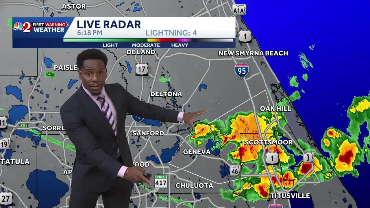
You've got some severe weather pushing into metro Columbia right now. This is a severe thunderstorm warning with 60 mph winds and hail that could grow up to almost 3/4 of an inch in size. Then you go up through Greenwood, Hodges, up through Promised Land, Bradley, Troy, Kirksey. Got some heavy rain moving up through uptown Greenwood and heading toward the lake right here. Then that's going to go into Laurens County. Then you go on up a little bit more into Anderson County. Some rains pushing into Greenville, Greer, Five Forks and Mauldin. Some good old fashioned heavy rain. But you go back here toward the core of this system. There is a strong weather statement here. This is winds up to 50 mph and this does include Gum Log, Lavonia, Lake Hartwell, getting into Oconee County, Hart, Elbert, Franklin, Stephens, Habersham, uh even up into southern Rabun County. So, this is the cell that we're going to be watching and really the the line of cells that we'll be watching that uh could turn severe.
In fact, this one right here across Stephens County appears to be our strongest one over Easton Alley. Uh that's pushing toward Westminster, Union, Seneca, and then eventually Clemson. So, uh what I'm going to do here now that I've kind of given you a tour where things are. Same story for the mountains as we're watching for some uh heavy rain to move into your neck of the woods. I'm going to do a couple of storm tracks on this answer your questions and then show you a couple of models with how the rest of the evening is going to pan out. Does that sound good?
And should there be another warning that pops up during this broadcast, we'll see it, you'll hear it. A little tone will come on. And again, just to reiterate if you're just joining, the two warnings for tornadoes that you're seeing are for the uh southwest of Atlanta area, okay?
So, just to reiterate that. All right, let's get in closer right here to uh the the core of the storm that's about to move through some of our most populated areas here across parts of uh the up state. What I'm going to do here is uh set the speed with some of this activity as it moves on through.
Uh here we go. All right.
Tallulah Falls through Toccoa Commerce, Lavonia, and Hartwell.
All right, what we're going to do is go out and the time about an hour here.
There we go. All right, so it's got storm projection timing here. Uh and again, this is the timing it expects it to be into these towns like Anderson within about 19 minutes.
Um and then Easley within about 30 minutes or so. So, we'll be watching that closely uh as the speed Let me bring that down just a little bit uh based on where we're seeing it uh fill on in here. So, about 40-45 mph speed.
Watching that closely. So, Walhalla within about 19 minutes, Seneca uh in about 20 minutes, you got Anderson roughly 30 minutes, Clemson about 30 minutes, Central down to Belton Honea Path, uh Liberty uh moving through these communities here through Williamston, Piedmont, Easley, Gantt, and then Welcome. So, watching that closely, I'll kind of throw in some more towns here. We'll be watching that uh as it moves on through these areas. Now, we're getting some reports back through uh Columbia and then stretching into parts of uh Atlanta metro for the potential of some of these causing uh some some some damage with trees down in and around the Atlanta metro area. So, the potential is there as this moves on through, especially over the next couple of hours as the atmosphere is still kind of ripe, as we call it, for for thunderstorms to move on through. Uh we got instability uh and quite a bit of it uh moving on through. So, uh again, Toccoa and surrounding areas, this appears to be kind of the strongest uh batch of storms that are rolling through uh these areas as we watch it uh through Elberton and northeast Georgia pushing east over the next hour or so.
Uh so, Seneca, about 20 minutes, Anderson 22 minutes, you got Clemson at about 20 25 minutes, Piedmont, Easley, Gantt, Welcome, Parker, Mauldin, Berea, Greenville at about an hour, which puts it roughly around 7:40 for some of the heavier uh batches to move on through uh as we see the storms rolling on through Sandy Springs, uh Simpsonville, Five Forks, uh these areas within the next 30 to 45 minutes. Uh watching that roll on through some of these areas uh very closely.
Uh and again, we're going to be watching this. Um winds would be the primary threat.
But again, right now, so far, these storms are behaving uh very um you know, to to a fault of almost 50 mph. So, getting close to that severe thunderstorm criteria. And of course, the folks at the National Weather Service doing a great job watching this and and timing it out town by town as we we watch this unfold. So, there's a tour of it. What I want to do is kind of show you how the west rest of the evening is going to to pan out.
Hopefully, that answers some of your questions as far as what we'll expect and then I'll go to your questions, okay? So, let's look closer at what's happening right now. There is a level two risk for flooding. Now, these >> This tornado warning has been issued.
>> These storms are rolling through right now are going to put down a lot of rain in a short period of time. to shift at some point 10-ish, maybe 10 to midnight, you know, slightly the pendulum's going to swing a little bit less towards storms, a little bit more toward flooding.
You know, you'll see that that shift happen there.
And we're going to get a lot of rain in in in, you know, the next three, four hours. And then it kind of continues to be steady into the overnight hours. And again, not that we have to see the pendulum swing all the way to flooding and no severe weather. I think there's going to be at least a small threat for severe weather through the entire overnight hours as the core of the system rolls overhead. That's why we do have a level two risk for severe weather.
As the core of the system actually rides right along a line here from Birmingham, right up the I-85 corridor to be honest with you, up through Atlanta and then directly overhead of Greenville. And on the the right side, Brad we've been calling it the the dirty side. It's it's the right and that south northeast quadrant >> severe thunderstorm warning has been issued.
>> the higher threats for storms in these locations. As we map that out, that right side of the storm is always the strongest as we move through. And as far as the model is concerned, this is what we call the high resolution rapid refresh. This corrects itself based on current data. So, what we have here is fresh data that's that's been adjusted based on the way things are kind of panning out in real time. So, what this shows is through 8:00 some of these storms rolling through Greenville, which matches up with what I just showed you on current radar. Shows you where we're seeing that fall through these areas. I think we just had a new uh continuation to the warning. I think it's down through Columbia. So, just want to check on radar real quick. I heard the the chimes there. All right. So, let's go to 9:00. You know, we got some rain in the area. We've got more pushing in from Atlanta metro. 10:00, 11:00. And again, as we go through 11:00 to midnight, not that the severe threat's over with. In fact, there could be some really feisty storms in Elbert, Abbeville, Greenwood counties as this rolls on through these areas.
Um and again, I'm hopeful that this is is just some good old-fashioned mild rain that we need. Our area desperately needs some good soaking rain. This will do a number on our drought situation that's ongoing right now. We just don't want it to be uh too much rain in a too short a period of time or getting any of these little squirrely birds to give us uh you know, a twisting, turning storm with some severe weather. Here's midnight.
Here's 1:00 a.m. And again, the core of the system actually going to ride right overhead. This severe thunderstorm warning has been updated.
With the core going overhead, it kind of pushes the strongest activity or or fuel just to our south and east. And again, not that it's gone for our area, but it's at least taming down just a little bit. Um so, when we go to bed tonight, of course, our team will be watching it.
Bradford and I are going to be here with you through the storm. Uh but right now, I think you know, we're going to see this shift into more of a a rain threat than a severe threat. All right. Let's Let's get to 2:00 a.m. You see some heavy rain. I mean, it's coming down outside. Um probably not a good idea. I had this little spot of seed in the yard.
It's probably going to wash that seed away. I mean, this is this is the kind of rain that you know, we call it gully washers, right? Uh tornado warning is in southwest of Atlanta right now. I do have on Georgia and Carolina's warnings.
Uh I couldn't get Georgia off. I wanted to leave Georgia on to be able to include northeast Georgia, uh but it is uh you know, unfortunately including Atlanta. So, for the crawl at the top and the bottom. So, you'll see those pop up where the actual warnings are and they're southwest of Atlanta near Columbia right now. Uh uh Columbus I should say. All right. So, as we go through 5:00 a.m., I think most of our area is dry. For you folks watching right now at the coast or those of you that are tuning in from uh Charlotte or the Midlands right now, uh this is going to continue to press east. I don't think your day is shot at the beach. In fact, you got your last beach day for many of you uh from the Grand Strand down to Charleston.
I think most of your day is fine after mid-morning. In fact, by beyond 9:00 10:00 things are things are looking up across the area. Let's talk about flooding for a second and then we'll look at the rotating nature of some of these storms and the potential there. Uh you know, this does a great job. This is the most recent run. Uh most of us are going to see an inch, but there going to be pockets here where we get repeated downpours. Like Oconee County, like Greenville County, where you know, town by town if you look at Greenville to Travelers Rest, there's a half an inch to an inch of difference. That's where you get these thunderstorms to set up and that's why there is a threat for flooding, but it's not going to be everybody. Like Stephens County, northeast Georgia, you know, Stephens County as small as the county is geography-wise, uh parts of Toccoa could be at almost 3 in, but this streak in pink here in southern Stephens County getting closer to Lavonia uh in the Lake Hartwell could be closer to 4 and 1/2 5 in. So, there will be pockets here that get in on some some heavier rain and give us a risk for flooding. All right. So, that's kind of an outlook as far as as we're concerned.
Let's get back to the radar. Let's kind of reset, look at what's going on, and we'll get to your comments, your questions, your concerns, and try to answer them best we can uh as we monitor the situation across the area. So, uh as it stands, uh kind of zooming on out, I'm going to turn on our nationwide um, you know, model for for for warnings here. And you can see back toward the west there are two tornadoes warnings south of Atlanta.
Okay? Then you go into this line right here and I've got the storm reports on.
So, as we see this line move through the Augusta area, it did put down some damage Aiken and then the Augusta area.
We got several reports of winds, large tree branches down in and around North Augusta, North Augusta police reporting a tree fell across two cars and took out some power lines at Chalet North Court. So, again, these these are these are bearing to to be watched and again another tree falling in front of police officers there at Lee Drive and Jansen Street. That's in the Augusta area. So, that's why this line right here does still have a warning on it, a severe thunderstorm warning and that's going to get into these areas. So, giving you an idea of what it's going to be like in and around Columbia.
Let's get a look at that.
All right. So, assuming it's moving at 45 mph, I'm going to move it over here.
I mean Saluda, Wagener, Prosperity, Gaston, Lexington, South Congaree, Casey, West Columbia in 45 minutes about 7:30-ish and then Metro Columbia downtown at about 7:30. So, that's that's some of the stronger storms there in the Columbia area for you folks watching right now. Let's go up the hill so to speak into the Upstate as we look at Greenwood, Honea Path,
Related Videos
Monday evening forecast | June 15, 2026
WBNS
384 views•2026-06-15
Monday evening First Alert Weather with Darren Peck 6/15/2026
cbssf
662 views•2026-06-16

Clouds build up tonight as we track a storm threat for Thursday
NBC10Boston
2K views•2026-06-17

Just One magnetic field power, two light start with Armechar • Dc Armechar
DcArmechar7
14K views•2026-06-17

What a Massive Blue Iceberg Actually Looks Like?
QuickLearnGeography
100 views•2026-06-18

Chicago Morning News at 7 a.m. - Monday, Jun. 15, 2026
FOX32Chicago
942 views•2026-06-16

The Terrifying Physics of High Blood Pressure
fleshandwonder
1K views•2026-06-15
Strong And Severe Thunderstorms Surge Across Central Florida To Finish the Workweek | Stormy Week...
WESH
806 views•2026-06-19


