Severe weather forecasting involves analyzing multiple atmospheric factors including wind shear, instability, and moisture levels to predict storm intensity and timing. Strong storm systems with low pressure (around 984 millibars) and significant wind shear can produce severe weather even with limited instability, as demonstrated by the slight severe weather risk forecast for Wednesday evening despite cooler temperatures. Meteorologists assess tornado risk using the Enhanced Fujita (EF) scale, which measures wind speed and damage potential, while also monitoring rainfall patterns and humidity levels to predict storm development and severity.
Install our extension to search inside any video instantly.
June 14, PM Weather Video Forecast
Added:Hi everyone, meteorologist Chad Evens here with a look at your daily weather forecast. Today is sponsored always by TNT Tree Service. Big thanks to Todd at TNT and as always, big thanks to all of you and a big thanks to all of our other sponsors as well. Now, these are the damage reports from the severe weather Thursday. Now, why am I showing you this again? Well, we had another tornado confirmed. It was here near Boswell in Benton County. Now, I don't have the exact track from the weather service out of Chicago. Uh but it was confirmed there was an EF EF1 tornado. We also have the brief EF0 up here northeast Carroll County and the brief EF1 up here southwest of Burrows. Also, in terms of wind damage, again, again, here are the tornadoes plotted. There's the EF1 at 90 near Burrows, the 70 mph EF0 northeast Carroll. There was a discrepancy a discrepancy on this tornado. One bit of data from the Indy office said 75 mph, one had 70, but the official what we call LSR read 70. So, I put that at 70 mph and uh the wind is not out on this EF1 just yet. It's just confirmed as an EF1. Now, the wind, these are the measured gusts. We had that measured gust 76 east of Fowler, 75 Kentland Air Airport, 85 near Brook and the 67 near Michigan Town, 71 west of Pine Village.
In the National Weather Service surveys, they found wind damage consistent with winds of 75 to 85 mph from Ambia to Talbot in southwest Benton County.
Again, straight-line wind damage. And then at Kokomo, we had a apparently two downbursts.
And one produced a gust up to 93 mph likely based on the damage on the west side of Kokomo and up to 90 mph on the east side of Kokomo. So, that's what we have at least right now. Now, in terms of rainfall, the biggest rain we're going to have this in well, over the next 14 days is Wednesday night.
Um overall, you you know, we've got a little bit more rain storm action ahead, but this is going to be a drier week compared to the past well, the past couple of weeks. We had what, six consecutive days of thunderstorms in the area with locally heavy rainfall and anywhere from more than two to 7 in of rain forecast area-wide, perhaps even a hair more than that.
Though we've got some severe weather risk back in, but temperature's not bad.
Held in check, a lot of them are going to be below normal until we start to heat up more at the very end of June into the start of July. Now, that will be a pretty muggy to oppressive heat, but it's not like we're getting to 96° or anything. We're probably going to have highs upper 80s to low 90s. The pollen, after medium high yesterday, the next several days it's in the medium range. Today we'll have a brief uptick in the UV by the end of the day here around 7. It does go up to eight tomorrow, though. So, high very high UV by tomorrow. With temperatures running right now, that 80 is not up-to-date right now at the Purdue Airport, but the Lafayette Timber House Airfield is 68.
It's 68 at Cutler, 73 Ketlin, 69 here at Kewanna, and it's 72 at Covington. We see some sunshine appearing. We see the cumulus clouds here, showers pulling away. If there's any other shower the rest of the day, it'd be quite isolated or very spotty just from these cumulus clouds coming in from the northwest. And there's the line of storms off to our east and the showers as well. There's that line over Ohio. For us, we're in good shape right now.
We had a few showers and storms in our far northern and northwestern counties last night. We had a couple down in our southwest counties yesterday evening.
And then today kind of a scattering of thunderstorms and some showers around as well. Randy had a half an inch of rain east of Frankfort. Some spots here in eastern Howard, eastern Clinton County picked up an inch of rain, but other spots a trace or a few hundred. So, highly variable rainfall over the area.
Here's some of that rainfall from last night.
Up here to our northwest, we had nearly 3 in up in Lake County, Indiana though.
And then some spots here along 24 that had more than a half an inch of rain.
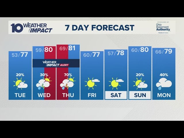
You can see in other spots 10th of an inch, 2/10 of an inch of rain since last night. Marginal risk of severe weather is actually up, not tomorrow. Tomorrow's a nice day. This is Tuesday.
3:00 to 8:00 p.m.
Uh for the risk of an isolated severe gust or a little bit of hail. You might be asking, "Well, Tuesday, the humidity is going to be low. It's not going to be that warm." This is cold air aloft.
Strong sun angle this time of the year.
There's going to be kind of a clipper system dropping this way, a cold front, and the cold air aloft will overlay the area just ahead of the cold front. So, we're going to be able to bubble up uh perhaps a a few spotty showers and thunderstorms around, especially along the cold front.
Then Wednesday, 6:00 p.m. to 3:00 a.m., slight risk of severe weather. There's the enhanced here Illinois out towards Missouri.
A couple or a few severe gusts, some hail, can't completely rule out a brief EF0 spin-up. It appears that the best severe weather risk is indeed southwest of our area, and slight risk looks good for us. So, here we are Tuesday, well clipper system zipping by here. The winds go briefly southwest and then they go back to the west and northwest, and we can see a few spotty to scattered showers and thunderstorms around, especially as the cold front comes through later on in the day for that risk of an isolated severe storm. When overall this week, temperatures are going to be running below normal, and that'll be the case even on Tuesday with that marginal risk. Uh cooler than normal weather expected, and that'll be the case even into Wednesday, Thursday, and Friday. And you say, "Well, why are we getting slight risk Wednesday then?"
Very strong storm system for the time of year. This thing's going to drop to about 984 millibar, maybe less than that in Michigan. Very tight, very strong March-April kind of strength.
And when you've got that much strength and this much shear, it's not going to take quite as much instability or warming to create severe weather.
Certainly, the worst of it's going to be down here. It's going to be Illinois all the way down into Missouri, this pocket down here enhanced risk, maybe a pocket of moderate. But we've got enough here for slight risk for severe. Now, for some reason, if the instability can increase more and overlay that shear a little bit more, we will have enhanced. But right now, slight looks good for us. We're going to have a round of storms that come through mainly late Wednesday evening and then into a Wednesday night with severe weather for our area and we'll be fine-tuning that forecast here in the coming days and then this feature yeah, that could be an early season tropical system that makes landfall in Texas. Now, why not Florida? Why not the Gulf Coast?
We've had Saharan dust around Florida and the eastern Gulf of Mexico putting the kibosh on tropical development. But here we don't have the Saharan dust as much and are still favorable for an early season tropical system and you can see that via here the National Hurricane Center update for the risk of a tropical system right here along the Texas coastline in the coming days. Rainfall Tuesday to Wednesday night. So we take Tuesday, we're also going to go ahead and just take Wednesday night, put them together and you see anywhere from 8/10 near an inch to as much as an inch and a half a few spots 2 inches or rainfall.
Then we dry out after that and we're dry through Friday. We're dry into Saturday.
May even be dry a good chunk of Sunday as well, but then shower storms come in the 26th and the 27th and the 29th through July 2nd. Hot upper ridge here with a pretty intense heat. We'll be right on the edge, right on the periphery and this whole area will see repeated rounds of shower storms and severe weather risk leading to the above normal rainfall. So your humidity dropping now in our area, it drops big time tomorrow.
It creeps up a hair Tuesday, skyrockets by Wednesday evening, Wednesday night, then tanks again. May come up a hair next weekend. We may have a weak clipper that kind of passes north of our area with a couple spotty showers, but nothing big and then it's dry and it stays comfortable for a while, but after June 25th, the oppressive to muggy humidity comes back in. Tonight, another thing I want to mention, there could be some patchy fog late given the moist ground conditions and the temperature down to 51.
A cool June night ahead with lows anywhere from 48, 49 to about 54°. So, cool night. Nice day tomorrow, winds out of the west, gusting 24 to 30 and a 75° high. 72 to 77 looks good for highs forecast area-wide. On Tuesday, a little warmer, 75 to 79. Again, the clouds bubbling up, the approach that cold front where we're overlaying that pocket of cold air as you go up. So, those clouds billowing and towering and bubbling up with a few showers and thunderstorms later in the day with that marginal risk. 77 though, that's it for the high and not really not overly humid. 75 up here to the north around like Rose Lawn and Winamac and Rochester to 78 at Attica.
Beyond that, so we go to Wednesday, humidity surges in but a high of 81.
Stormy late evening and end of the night. Few showers early Wednesday, humid then humidity drops off. Nice Friday, Saturday. Much of Sunday is nice, maybe a touch a touch humid, but not a big deal Sunday. There'll be a couple of spotty thunderstorms late with that little clipper we talked about, the second one. And then it's dry and comfortable before the storminess and the high humidity return after June June the 25th.
Related Videos
Monday evening forecast | June 15, 2026
WBNS
384 views•2026-06-15
Monday evening First Alert Weather with Darren Peck 6/15/2026
cbssf
662 views•2026-06-16

Clouds build up tonight as we track a storm threat for Thursday
NBC10Boston
2K views•2026-06-17

Just One magnetic field power, two light start with Armechar • Dc Armechar
DcArmechar7
14K views•2026-06-17

What a Massive Blue Iceberg Actually Looks Like?
QuickLearnGeography
100 views•2026-06-18

Chicago Morning News at 7 a.m. - Monday, Jun. 15, 2026
FOX32Chicago
942 views•2026-06-16

The Terrifying Physics of High Blood Pressure
fleshandwonder
1K views•2026-06-15
Strong And Severe Thunderstorms Surge Across Central Florida To Finish the Workweek | Stormy Week...
WESH
806 views•2026-06-19


