Low pressure systems off the coast create counterclockwise spinning air patterns that allow the marine layer to deepen and travel inland, bringing cooler temperatures to the Bay Area; this phenomenon explains why coastal areas remain cooler while inland microclimates experience warmer temperatures, with temperature differences of 10-12°F typically observed across the bay.
Install our extension to search inside any video instantly.
Friday evening First Alert Weather forecast with Darren Peck - 6/19/2026
Added:All right, switching gears talk about our weather. It's the weekend or almost there at least and you have your eyes >> Right there.
>> On this.
>> Good eye. Yeah, yeah.
>> What's going on here?
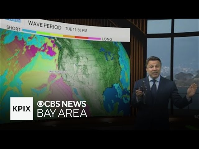
>> Little counterclockwise spinning the clouds right there. Now, watch watch yourself. Watch yourself cuz there comes the big red cylinder behind it.
>> Oh. You know this scares me.
>> Don't touch it.
>> I wouldn't dare.
>> Um but it that's a really important feature. This is the coolest day that we've had in a while. There are places like the warmest inland microclimates only low 70s today.
Marine layer was pretty thick, although it did give us more sunshine actually near the bay. But we pulled in more cool air today than we've had in a while because of this thing which almost zapped Liv when she was standing next to it. We're pointing out that counterclockwise spin. This is just one other way to visualize low pressure when it's off the coast. It is a column of rising air through the entire atmosphere. And that rising air allows the marine layer to go up with it. It gets deeper. And when the marine layer gets deeper, just it's just intuitive to think about this in that way. When the marine layer gets deeper, it's now able to get over the peninsula, the mountains, the Santa Cruz mountains, over the East Bay hills, and it's really able to travel inland to these valleys and transport much cooler air, which is what it did today. So, we're going to do almost the same thing tomorrow. I'll show you the progression as we get into Saturday. Here's first part of your weekend. Pretty much the same thing only a little less.
It's not going to be quite as cool tomorrow. We're going to have to warm up just a little bit. I'm not saying it's going to be hot, but we are going to warm up about 3 or 4 more degrees from where we were. So, what we should do is just skip ahead and I'll show you what the daytime highs are going to be for our inland microclimates by the time we get to tomorrow. Hmm. And we'll start out by taking a look at that first. So, let's get Saturday's numbers on here.
I'll get out of the way. Go ahead and pick out your part of the bay. We'll start out down in Monterey, in Santa Cruz. These numbers warm up by about 3 or 4 degrees from where you were yesterday. Nothing drastic, but it is a trend because as we get into Sunday, the numbers are going to go up about another 3 or 4° from that. In fact, let me switch this out. Watch what happens when we look at the line tomorrow.
I call this affectionately the line going from Half Moon Bay out towards Antioch. This transect across the bay illustrates the microclimates beautifully. When we get into a situation where there actually is warmth like intensifying, you can at at its most extreme you get a 40° temperature spread here. We don't have that at all.
It's more like a 10 to 12° difference from one side of the bay to the other.
All right, that's where we're going to be tomorrow. Nothing too crazy. Let's take a look at where we're going to be on Sunday.
There's a little more green along the coast and when we put Sunday's highs on, inland we are a little bit warmer and near the water we're a little bit cooler. So, we're increasing that spread. There is more of a a difference from coast to inland, but it's still nothing too drastic. Let's just get into the 7-day forecast to see how long we'll be doing this.
We're going to have temperatures that warm back to the mid-80s once we get into the middle part of next week. So, we are going up and that's why I was saying that today was the coolest day.
It was the coolest day we've had of the last several days. It's also the coolest day we're going to have. Easily for the next 7 days and probably longer. Today was was notably cool for for many of those warmer microclimates. You won't notice a whole lot of difference if you are bayside.
The story of dramatic change really plays out inland. So, when we look at the forecast for the bay, if we can get that to switch out, it's going to be almost identical to yesterday and today and tomorrow. If you're on the peninsula in the city, these days are not really showing much difference in character. Although, we'll get a little warmer generally by the middle of next week. All right, Liz, back to you.
Related Videos
Monday evening forecast | June 15, 2026
WBNS
384 views•2026-06-15
Monday evening First Alert Weather with Darren Peck 6/15/2026
cbssf
662 views•2026-06-16

Clouds build up tonight as we track a storm threat for Thursday
NBC10Boston
2K views•2026-06-17

Just One magnetic field power, two light start with Armechar • Dc Armechar
DcArmechar7
14K views•2026-06-17

What a Massive Blue Iceberg Actually Looks Like?
QuickLearnGeography
100 views•2026-06-18

Chicago Morning News at 7 a.m. - Monday, Jun. 15, 2026
FOX32Chicago
942 views•2026-06-16

The Terrifying Physics of High Blood Pressure
fleshandwonder
1K views•2026-06-15
Strong And Severe Thunderstorms Surge Across Central Florida To Finish the Workweek | Stormy Week...
WESH
806 views•2026-06-19


